TRANSPLAN50 GOAL 1
Update the Regional Highway System to a Metropolitan Grid-Based Network
HISTORIC HIGHWAYS CONNECTIONS AND DEVELOPMENT

Historic Highway Connections
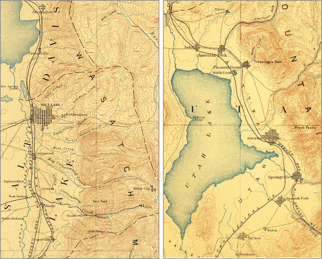
To understand how Utah County’s regional highway network developed, one can look to its neighbor to the north. Salt Lake County grew from downtown Salt Lake City outward establishing regional transportation corridors with well spaced and sized highways.
Utah County has a more rural focused highway system. Its history started with nodal settlements with each town focusing on its own road systems. The state built the main connecting highway between the cities. As the towns grew and began adjoining each other, the proper sizing and spacing of regional highway connections, in most cases, did not occur – the local street network was not complemented by a regional grid.

"Because a connected regional highway grid did not develop as the county urbanized, some developed areas could be impacted to make the connections needed for future growth"

NEW, DEVELOPING AREAS

CONGESTED CHOKEPOINT AREAS
Transportation Choke Points
Utah County has a unique geography with its towering mountains, lakes, and wetlands. These features create a unique geographic environment making transportation connections a challenge. In the county, there are five areas where transportation corridors must traverse within narrow strips of land bordered by these features called transportation choke points.
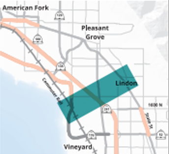
LINDON CHOKE POINT
The Lindon Choke Point today has the highest traffic volumes in the valley with a significant commuter movement between the central and northern areas of the county.
With only three highway corridors, State Street, I-15, and Geneva Road, as well as FrontRunner Commuter Rail, this is an important area to focus on relieving congestion. TransPlan50 proposes improvements to 1-15 and commuter rail in this area as well as the addition of light rail and bus rapid transit along State Street.
DESIGNING A REGIONAL HIGHWAY GRID NETWORK
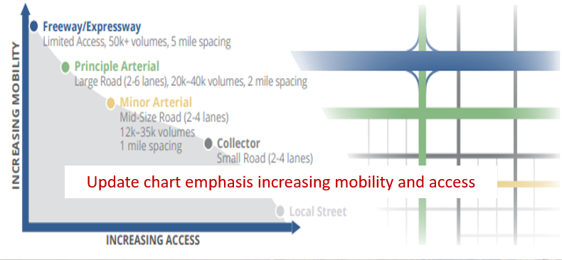
Recognizing the challenges greenfield areas face as they urbanize, the Institute of Transportation Engineers (ITE) created a Best Practice recommendation for macrolevel network spacing, that if adhered to, would minimize congestion on any given facility. The thought is that having a grid of properly spaced roads that can handle different types of trips (local to sub-regional to regional), that traffic would be spaced out easing congestion and dispersing traffic more evenly throughout the area avoiding placing all traffic on just a few major corridors. The hierarchy of a regional highway network starts with Freeways and Expressways. These corridors are the highest mobility corridors have characteristics that include grade-separated interchanges (Expressways can have signaled intersections), higher traffic volumes, higher speeds, limited access, and are ideally 5 miles apart. Principal Arterials are the higher mobility corridors carrying regional traffic, high volumes, generally have controlled access (fewer driveways), and higher speeds. Minor arterials have lower speeds and more access points. Collectors have lower volumes and even more access.
HOW TO DESIGN THE HIGHWAY GRID SYSTEM
MOBILITY VS. ACCESS
HOW IT WOULD LOOK OVERLAYED OVER UTAH COUNTY
ITE HIGHWAY GRID SPACING OVER UTAH COUNTY
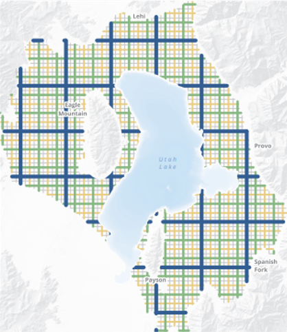
PROPOSED UTAH COUNTY GRID
It is estimated that completing the countywide urban grid network as proposed requires an additional 1,000 miles of new lanes. A quarter of these lanes are in current built-up urban areas with the remainder in greenfield areas. The proposed grid also removes about 750 structures, more than half of which are located in rural areas and will most likely be incorporated into future developments. The total cost of the grid network is estimated at upwards of $2 billion dollars, not including projects already proposed and funded in TransPlan50. Of this cost, $500 million is anticipated within the built-up urban areas. Most of the $1.5 billion to build the grid in the rural areas will be funded by private development if properly planned for. Moving forward, MAG will work with our stakeholders to identify which projects can be adopted into municipal and regional plans. More importantly, funding to construct the collectors proposed in the grid network will have to be identified. Currently, only local and regional funds can be used in funding these types of facilities, with these funds already stretched thin. State-wide solutions will most likely need to be sought to these regional non-state-owned roads in the future
BENEFITS OF A CONNECTED HIGHWAY GRID
The benefits of relieving regional congestion by completing the grid network are high. With the proposed growth to 2050, overall travel delay in the region increases elevenfold compared to 2018. To put this in perspective, Salt Lake County in 2018 had five times more congestion related delay than Utah County. Modeling shows that with a connected arterial and collector grid network with no additional freeways, the 2050 travel delay would only grow to seven times that of today. With the addition of the proposed freeways in the plan, congestion rises to only three times the current delay, well within acceptable limits of a metropolitan area of 1.3 million people.
11X
More Delay than Today
Utah County
Without Grid
5X
More Delay than Utah Co
Salt Lake County
Today
2X
More Delay than Today
2040 Utah
Co Goal
TRAVEL TIME DELAY
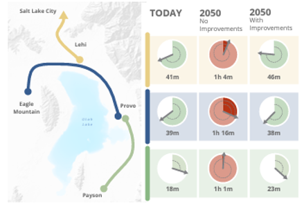
Travel Time Delay
Another way to understand future network conditions is with travel time. In 2018 a trip by automobile between Eagle Mountain and Provo took about 39 minutes. With no improvements, by 2050 the same trip takes 1 hour and 16 minutes; Provo to Payson 18 minutes versus 1 hour, and Lehi to Salt Lake City 41 minutes versus 1 hour.
“Congestion increases exponentially without system improvements”
DISPERSING TRAFFIC
The reason a network of arterial and collector roads works is its ability to spread out traffic. Today the North and Central areas are connected by three main corridors, all state routes; I-15, State Street (US-89), and Geneva Road (SR-114). By creating additional connections of smaller roads in this area, localized trips would no longer be required to traverse the major roads, thereby reducing congestion. Connecting collectors and arterials does not necessarily lead to heavy traffic on these roads, rather, by spreading trips out, the total volumes of traffic on a single corridor can be reduced.